
Framed Memories # 34
Photo Gallery


Share this:

Photography of Birds – Set # 229
Set # 229
Yellow-crowned Night Heron

Yellow-crowned Night Heron
The Yellow-crowned Night Heron looks for shallow water to live in: marshes, wooded swamps, and lakeshores for inland populations, and thickets, mangroves and cliff-bound coasts for coastal populations. It can also be found in areas that don’t always have enough water, but that get flooded on a regular basis. Its habitat is closely linked to that of the crustaceans that make for most of its diet, and it tolerates fresh water, brackish water and saltwater. Another important habitat factor is nesting sites. The yellow-crowned night heron needs bushes or trees to build nests, although it will use rock ledges where vegetation is unavailable (for example, on cliffs). Unlike the black-crowned night heron, the yellow-crowned does not mind living near humans and can be found in wooded neighborhoods, nesting on rooftops and driveways. Such cohabitation may not go smoothly and can create conflicts with humans.
Snowy Egret

Snowy Egret
Snowy Egrets breed in mixed colonies, which may include great egrets, night herons, tricolored herons, little blue herons, cattle egrets, glossy ibises and roseate spoonbills. The male establishes a territory and starts building the nest in a tree, vines or thick undergrowth. He then attracts a mate with an elaborate courtship display which includes dipping up and down, bill raising, aerial displays, diving, tumbling and calling. The immediate vicinity of the nest is defended from other birds and the female finishes the construction of the nest with materials brought by the male. It is constructed from twigs, rushes, sedges, grasses, Spanish moss and similar materials and may be 15 in (38 cm) across. Up to six pale bluish-green eggs are laid which hatch after about 24 days. The young are altricial and covered with white down when first hatched. They leave the nest after about 22 days.
Fossils of the snowy egret have been reported from the Talara tar seeps of Peru and in Bradenton in Manatee County and Haile XIB in Alachua County in Florida, United States. The deposits were dated to the Late Pleistocene.
© HJ Ruiz – Avian101
Share this:

Photography of Birds – Set # 228
Set # 228
Muscovy Duck

Muscovy Duck
“Muscovy” is an old name for the region of Russia surrounding Moscow, but these ducks are neither native there nor were introduced there before they became known in Western Europe. It is not quite clear how the term came about; it very likely originated between 1550 and 1600, but did not become widespread until somewhat later.
In one suggestion, it has been claimed that the Company of Merchant Adventurers to New Lands traded these ducks to Europe occasionally after 1550; this chartered company became eventually known as the “Muscovy Company” or “Muscovite Company” so the ducks might thus have come to be called “Muscovite ducks” or “Muscovy ducks” in keeping with the common practice of attaching the importer’s name to the products they sold. But while the Muscovite Company initiated vigorous trade with Russia, they hardly, if at all, traded produce from the Americas; thus, they are unlikely to have traded C. moschata to a significant extent.
Ruddy Duck

Ruddy Duck
The Ruddy Ducks are small, compact ducks with stout, scoop-shaped bills, and long, stiff tails they often hold cocked upward. They have slightly peaked heads and fairly short, thick necks. Male ruddy ducks have blackish caps that contrast with bright white cheeks. In summer, they have rich chestnut bodies with bright blue bills. In winter, they are dull gray-brown above and paler below with dull gray bills. Females and first-year males are brownish, somewhat like winter males but with a blurry stripe across the pale cheek patch. In flight, ruddy ducks show solidly dark tops of the wings.
© HJ Ruiz – Avian101
Share this:

Special Places # 5
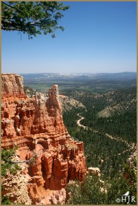
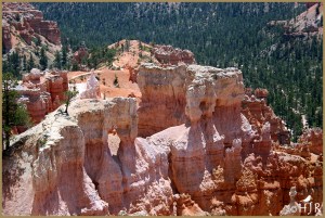
Bryce Canyon National Park
Bryce Canyon National Park lies within the Colorado Plateau geographic province of North America and straddles the southeastern edge of the Paunsaugunt Plateau west of the Paunsaugunt Fault (Paunsaugunt is Paiute for “home of the beaver”). Park visitors arrive from the plateau part of the park and look over the plateau’s edge toward a valley containing the fault and the Paria River just beyond it (Paria is Paiute for “muddy or elk water”). The edge of the Kaiparowits Plateau bounds the opposite side of the valley.
Bryce Canyon was not formed from erosion initiated from a central stream, meaning it technically is not a canyon. Instead headward erosion has excavated large amphitheater-shaped features in the Cenozoic-aged rocks of the Paunsaugunt Plateau. This erosion exposed delicate and colorful pinnacles called hoodoos that are up to 200 feet (60 m) high. A series of amphitheaters extends more than 20 miles (30 km) north-to-south within the park. The largest is Bryce Amphitheater, which is 12 miles (19 km) long, 3 miles (5 km) wide and 800 feet (240 m) deep. A nearby example of amphitheaters with hoodoos in the same formation but at a higher elevation, is in Cedar Breaks National Monument, which is 25 miles (40 km) to the west on the Markagunt Plateau.
Location |
Garfield County and Kane County, Utah, United States |
Nearest city |
Tropic, Panguitch |
Coordinates |
Coordinates: 37°37′42″N 112°10′04″W |
Area |
35,835 acres (145.02 km2)[1] |
Established |
February 25, 1928 |
Photo Gallery


© HJ Ruiz – Avian101
Share this:

Read Past Reviews

Book # 69

Quote from the Author
“A good chuckle is healthy, it helps you break the monotony of a serious life.” ~ H.J. Ruiz

You must be logged in to post a comment.